| |
Named as Parham
(also called Port Parham in some sources) is a town and a locality in
the Australian state of South Australia located on the eastern coastline
of Gulf St Vincent about 63 kilometres (39 miles) north-northwest of
the state capital of Adelaide and about 23 kilometres (14 miles) west
of the municipal seat of Mallala.
Parham was proclaimed as a government town
on 7 July 1876 with its boundaries being extended on 24 January 1980.
The boundaries for the locality of same name and which includes the
extent of the government town were proclaimed on 5 June 1997. It is
reported as being named after John Pocock Parham, an early settler who
arrived in South Australia in 1839. It was also historically known locally
as Dublin Beach. It was known as the Dublin landing place as early as
1871. with shipping recorded from 1870s. Prior to the Government Town
and well before the railway reaching Calomba and Long Plains, Parham
was the site of a major port for shipping grain to Port Adelaide from
the Northern Adelaide Plains.
The 2016 Australian census
which was conducted in August 2016 reports that Parham had a population
of 216 people.
Today, Parham is a holiday and recreational fishing settlement, famous
for blue swimmer crabs. In the past it was a port for Ketches shipping
grain, for shell grit and for the transport of essencial goods for the
community..
Parham is located within the
federal division of Grey, the state electoral district Narungga, and the
local government area of the Adelaide Plains Council.
https://en.wikipedia.org/wiki/Parham,_South_Australia
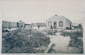
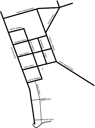
In the 1950’s the town
consisted of the original survey of 1876 bounded by the Esplanade, and
South, North and East Terraces, and “Port Parham South” which
were leasehold allotments released c1947 by the District Council of Mallala
The formed roads were The Esplanade from Second Street to Wilson Street,
First Street/Port Parham Road to Dublin, Main Street from The Esplanade
to East Terrace and then via Tickera Road to North Parham Road to “John
Bakers” on Port Wakefield Road, East Terrace from Fist St to Main
St, and what was known of as “Military Road” which passed
through private property north of Main Street from what is now 3 Main
Street to the Proof Range. This was the primary access to the Webb Shellgrit
reclamation pits north of the town. Those “developed” allotments
north of Main St were accessed by tracks through the bush.
Old Port Parham, the allotments were mainly the original ½ acre
surveys with Lot Numbers.
“Port Parham East” was parklands that were subdivided by the
Mallala District Council and allocated c1962. This area is bounded by
First St, Second St, Driscoll Terrace and East Terrace and includes Richardson
St.
|
A TIMELINE
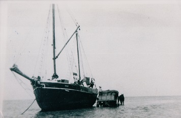
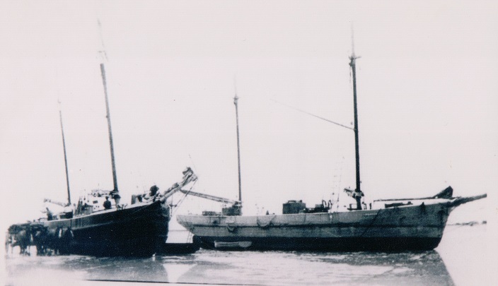
1837: First ketches in St Vincent Gulf
1851 first settlement of interior
1856 Hundred of Dublin surveyed and officially named
1870 George Baker loaded first grain at “Dublin Shipping
Place”
1876 Survey of the town of “Parham”. Bakers Creek first
appears on maps
27 June 1876 “Parham” officially gazetted
1880’s Port Parham at peak of activity, number of houses and
barns built for the grain trade
C1905 James Nairn of Grace Plains build substantial dwelling at
56 The Esplanade
1905 George Long identifies a horse that swam from Ardrossan
1918 two men lost at sea, the crew of the ketch “Buck”
C1920 Theodore Graue of Willaston builds substantial dwelling at
70 The Esplanade
1924: Port Wakefield Proof and experimental Range established
C1927 Webb’s Carbonate of Lime established
C1933 Webb Family move to Port Parham
1938 King Tide results in the creation of First and Second Creeks
(later known as Parham and Webb Creeks)
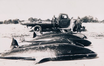
1943: Pilot whales beached
1943 Avro Anson crashes at sea, no survivors
C 1947 crown land south off South Terrace surveyed and released
for coastal lease
1948 Last ketch takes grain from Port Parham
C 1950 Port Parham Progress Association established
C1958 Methodist hall built
C1960 Whimpress family establish shop and kiosks
C1964 Mains power provided
C 1964 land east of East Terrace Subdivided and sold by Mallala
District Council
C 1968 Catholic retreat established
1968 King tide results in flooding of township
1970’s Webb Beach established under RED (Rural Employment
Development) sheme
1982 Australian Government attempts to resume the town for extension
of the proof range.
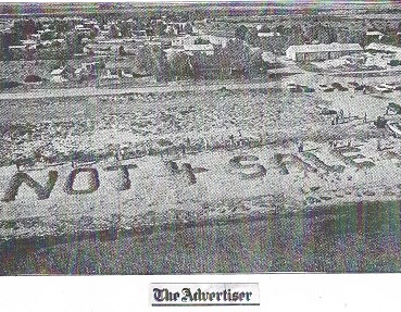
1986 Community action results in the government backing down on
extension
1984 Port Parham sports and Social Club established
1990: Club building opened
1991 mains water reticulation provided
1993 Council bans camping on the foreshore: Port Parham and Webb
Beach Progress Association formed
1996 Parham Camp ground established
2011 Fin Whale beached
2017 PADAG established
2018 Adeliade International Bird Sanctuary established
2020 Jinker Centre/Interpretative Centre established
2023 Camp Ground restored and placed under the management of the
Lions Club and PADAG
|
|
